
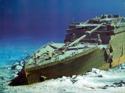
Archive artwork: this is not a photograph of the wreck’s present condition or an offer of a tourist dive.
Start with the expedition description
NOAA’s page about the August 2010 expedition describes mapping the wreck site. First establish when the data was collected and the researchers’ aims. These details help distinguish scientific work from travel advertising and prevent an old image being mistaken for footage recorded today.
Read maps alongside their explanations
NOAA’s results section presents mapping and underwater data-processing materials. Examine scale, labels and how an image was produced. A site overview answers a different question from a close-up of a detail; an impressive three-dimensional image does not by itself explain every component’s condition.
Distinguish photography from reconstruction
Identify an image’s origin: vehicle footage, a processed model or a drawing. This article’s cover is archive artwork. It does not establish the wreck’s present appearance, access or an operating tour. In your own account, retain the caption and date of the particular research material.
Explore educational resources at home
NOAA Ocean Today offers a wreck-site video with a transcript. Start there, then compare what you saw with the map and list questions: which part is shown, where is the viewpoint, and when was the data obtained? This approach supports independent learning about underwater archaeology without buying an expedition.
Treat the site as heritage
A story about the ship can focus on history, research and remembrance rather than collecting trophies. No dive itinerary is offered here, and former prices or tour availability are not confirmed. When sharing a research image, check its reuse terms separately: public viewing does not authorise every form of republication.